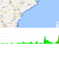
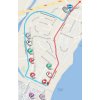
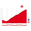
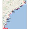
Stage 9 in the 2017 Vuelta España is a copy of the route of the 7th stage in 2015. Although the road book claims that the race commences 30 kilometres inland in Orihuela, the actual start is in coastal town Torrevieja. The riders pass through Benidorm and then continue to Calpe, winter-base to a lot of pro-teams. Last year the ITT was played out in this area with Chris Froome powering to victory.
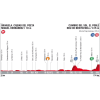
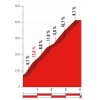
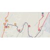
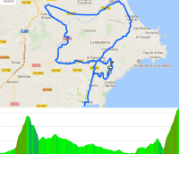
Almost 20 kilometres after Calpe the route takes in the first climb up the Alto de Puig Llorença in Cumbre del Sol, which is a residential area in Benitachell. It starts at a roundabout and soon the riders face ramps of up 21%. The first climb goes to an elevation of 350 metres. Still approximately 40 kilometres left to race.
Following a local round the climb up Alto de Puig Llorença appears again. This time the ascent is longer as the route takes in a dead end to the weather station at the top, amounting to 4 kilometres with an average gradient of 9.1%.
Two years ago the Cumbre del Sol was an unprecedented ascent in the Vuelta. When a bunch of escapees was reeled in on the lower flanks of the closing climb both Quintana and Valverde went on the attack, but to no avail. Then Dumoulin was off for a strong solo effort, yet the Dutchman was caught by Chris Froome and Purito Rodríguez with 200 metres left. At the eleventh hour he came back from the dead to grab both stage win and leader’s jersey.
The first three riders on the line take time bonuses of 10, 6 and 4 seconds, while the intermediate sprint (at kilometre 160) comes with 3, 2 and 1 seconds.
Read also: results/race report 9th stage 2017 Vuelta.
Vuelta 2017 stage 9: Route maps, height profiles, and more
Click on the images to zoom
