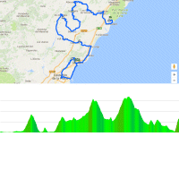
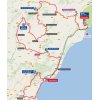
Coastal town Benicassin is located almost 100 kilometres to the north of Valencia. The area is bursting with fruit trees – oranges, lemons, tangerines – and while heading inland the riders will see olive plantation and pine trees. Stage 17 in last year’s Vuelta passed through Benicassin early in the race.
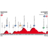
The first obstacle is Alto del Desierto de las Palmas, a 2nd category climb that’s crested with 23.8 kilometres done. Via Alto de Cabanes (3rd category), Coll de la Bandereta (2nd category) they stumble upon Alto de la Serratella. This 2nd category climb takes the riders in around 13 kilometres to an elevation of 840 metres. The first part is steepest, the ascent flattens out near the top, while the average slope is 3.8%.
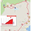
For almost 50 kilometres the route takes in rolling and descending sections before the riders hit the irregular closing climb to Ermita Santa Lucia near Alcossebre. At 3.4 kilometres, the hill is averaging 9.7%. At almost 15%, the first part is steepest, while the final 1,600 metres go up at 5%.
Ermita Santa Lucia has been build near the top of Sierra d’Irta. Beautiful views over Alcossebre and the Mediterranean Sea.
The first three riders on the line take time bonuses of 10, 6 and 4 seconds, while the intermediate sprint (at kilometre 160.2) comes with 3, 2 and 1 seconds.
Read also: results/race report 5th stage 2017 Vuelta.
Vuelta 2017 stage 5: Route maps, height profiles, and more
Click on the images to zoom
 Scheduled times 5th stage
 Benicassim and Ermita St. Lucia at Google Maps
 Streetview Ermita Santa Lucia
 Instagram @lavuelta

Videos La Vuelta

Video: highlights 2016
 Vuelta a España Tweets


In holiday in Alcossebre – drove up to the church where Stage 5 will finish on weds. Have to say, the car struggled to get up in several places – brutal!