Tour of Valencia 2023 Route stage 4: Burriana - Alto de la Cueva Santa

Slideshow 1/6
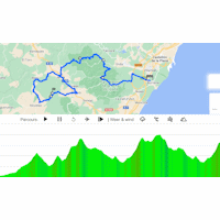
Saturday 4 February - The 4th stage is the race with the most vertical gain on the Tour of Valencia. The riders are to conquer 3,600 climbing metres on the road from Burriana to El Santuario de la Cueva Santa. The finish climb is 7.4 kilometres long and averages 4.7%.
The route climbs false flat from the start and gets slightly steeper after 12 kilometres. But still, the 17.4 kilometres climb at 2.9% to Aín is everything but a leg-breaker.
Right after the descent the route continues onto the Collado de Ayódar, a 4.8 kilometres climb at 4.3%. A slighlty shorter descent leads to the base of a long and irregular ascent. It totals 13.1 kilometres and the average gradient sits at 3.7%. The first 5 kilometres go up at 6% before the next 5 kilometres are as good as flat. Shortly after moving through the village Torralba del Minar the gradients kick up again to approximately 7%.
A long descent takes the riders to the foot of what will be the finish climb in 70 kilometres time. The Alto de Montmayor is 9.6 kilometres and averages 4.8%. Some 2 kilometres before the summit the riders pass the Cueva Santa Monastery, which will be the finish line later on.
After cresting the Alto de Montmayor the route continues with a short downhill, a rolling section and a 6 kilometres climb to the highest point of the day, which is situated at almost 1,000 metres above sea level. At this point there are still 50 kilometres to go.
A huge descent – with some intermediate climbs to pep things up – leads back to the base of the finish climb. As the finish is situated near the Cueva Santa Monastery – or, El Santuario de la Cueva Santa -, the ascent is 7.4 kilometres long and the average gradient sits at 4.7%.
The first three riders on the line gain time bonuses of 10, 6 and 4 seconds, while the intermediate sprint (MV in underneath profile) comes with 3, 2 and 1 seconds.
Ride the route yourself? Download GPX stage 4 Tour of Valencia 2023.
Another interesting read: results 4th stage 2023 Tour of Valencia.
Tour of Valencia 2023 stage 4: routes, profiles, more
Click on the images to zoom
+ Click for more images (2)
Watch the highlights of recent races here:
Related articles GC Favourites - Tour of Valencia 2023 Overview - Tour of Valencia 2023 Costa outguns Arensman on the line to win the GC - Tour of Valencia 2023 Velasco wins from the breakaway, Ciccone still leader - Tour of Valencia 2023 Ciccone wins on Alto de Pinos to take race lead - Tour of Valencia 2023 Route stage 1: Orihuela - Altea - Tour of Valencia 2023 Route stage 2: Novelda - Alto de Pinos - Tour of Valencia 2023 Route stage 3: Betera - Segunto - Tour of Valencia 2023 Route stage 5: Paterna – Valencia - Tour of Valencia 2023 Girmay sprints to triumph and leader's jersey - Tour of Valencia 2023 More articles Tour de Romandie 2025: Live report stage 1
Tour de Romandie 2025 Route stage 1: Münchenstein – Fribourg
Tour de Romandie 2025: Riders
Tour de Romandie 2025 Route stage 2: La Grande Béroche
Tour de Romandie 2025 Route stage 3: Cossonay - Cossonay
Tour de Romandie 2025 Route stage 4: Sion - Thyon 2000
Tour de Romandie 2025 Route stage 5: Geneva - Geneva
Giro 2025: The Route
Giro 2025: Riders
Giro 2025: GC Favourites
Giro 2025 Route stage 1: Durazzo - Tirana
Giro 2025 Favourites stage 1: Puncher's sprint for pink
Giro 2025 Route stage 2: Tirana - Tirana
Giro 2025 Favourites stage 2: Chrono specialists to the fore
Giro 2025 Route stage 3: Valona – Valona
Giro 2025 Favourites stage 3: Breakaway day
Giro 2025 Route stage 4: Alberobello – Lecce
Giro 2025 Favourites stage 4: For fast men #1
Giro 2025 Route stage 5: Ceglie Messapica - Matera
Giro 2025 Favourites stage 5: For fast men #2
Giro 2025 Route stage 6: Potenza - Naples
Giro 2025 Favourites stage 6: Hilly race with flat finale
Giro 2025 Route stage 7: Castel di Sangro - Tagliacozzo
Cycling Calendar 2025
Tour de France 2025: The Route
Tour de France 2025 Route stage 1: Lille - Lille
Tour de France 2025 Route stage 2: Lauwin-Planque - Boulogne-sur-Mer
Tour de France 2025 Route stage 3: Valenciennes - Dunkirk


